
Other interesting comments from the Contribution section. Information about our services.
Other interesting comments from the Contribution
section. Information about our
services.
SOME BASIC INFO ON BANAT
The historical Banat0 was almost a perfect square of 28.5261 km2 and had the following natural boundaries:
-at N the Mureş / Maros / Mieresch1 River;
-at E the foothills of the Carpaţi Mountains / Transylvanian Alps;
-at S the Dunãrea / Danube / Donau1 River;
-at W the Tisa / Tisza / Theiss / Theiß1 River.
For old maps go to the home page of HUNGARIAN CARTOGRAPHY where you can find also the excellent COUNTY MAPS of the Habsburg/Austro-Hungarian Empire at the beginning of XX century (you can chose between Gonczy maps & Osztrak-Magyar Monarchia varmegyei a XX szd. elejen maps), and you can located the Banat villages in Torontal, Temes or Krasso-Szoreny Varmegye/Counties.
At DONAUSCHWABEN2 VILLAGES LIST Web Site is to be find a short description of each village in Banat.
Between:
-1716-1778 Banat was direct ruled by the imperial administration from Vienna [military administration 1718-1751; civil administration 1751-1778]; it is correct to say that Banat was an Habsburg House possession.
-1778-1848 Banat was incorporated to Hungary; the head of the Habsburg House was also the king of Hungary.
-4.03.1849-27.12.1860 Banat [inside the Vojvodatu Serbico et Temesiensi Banatu (in Latin language3); set up by the Imperial Constitution issued on 4.03.1849 at Olmutz / Olomouc; ceased to exist on 27.12.1860 when, by Imperial Decree, the region was re-annexed to Hungary] was ruled directly by the imperial administration from Vienna;
-1860-1919 Banat was formally a part of Hungary [after the Ausgleich, in fact only starting 27.12.1867, inside the imperial dualism of Austro-Hungarian Monarchy].
-starting
1779, from administrative point of view, in Banat existed 3 counties
[or "varmegye"/"megye" in hungarian; "comitat"
in german and romanian]:
-Torontal [13.07.]
-Timiş / Temes [22.06.]
-Caraş / Krasso [5.08.]. Starting 18814 Caraş-Severin / Krassó-Szörény.
-1919- after WW I, the historical Banat was split between:
-România [2/3; 18966 km2; Temes Varmegye lose it's South part];
-the Kingdom of Serbs, Croats, and Slovenes [country known after 1929 as Yugoslavia] [1/3; almost all Torontal Varmegye; only the NE part of the comitat was incorporated to Timiş County/România] and
-Hungary [284 km2; meaning 1% of the total].
-in
România, the new county was named Timiş-Torontal [on 13.06.1925].
-in 1929 [on 29.07.], the existing counties formed the Timiş Province: Timiş-Torontal,
Caraş, Severin, Arad, and Hunedoara.
-in 1950 [on 6.09.], instead of the province, was enforced the Timişoara Region
[formed by today's counties Timiş and Caraş-Severin].
-in 1956, half of the existing Arad Region [the south] was incorporated to Timişoara
Region.
-in December 1960, Timişoara Region was named Banat Region.
-Starting 17.02.1968, a new territorial division was made in România and today's
Timiş, Caraş-Severin and Arad Counties were formed.
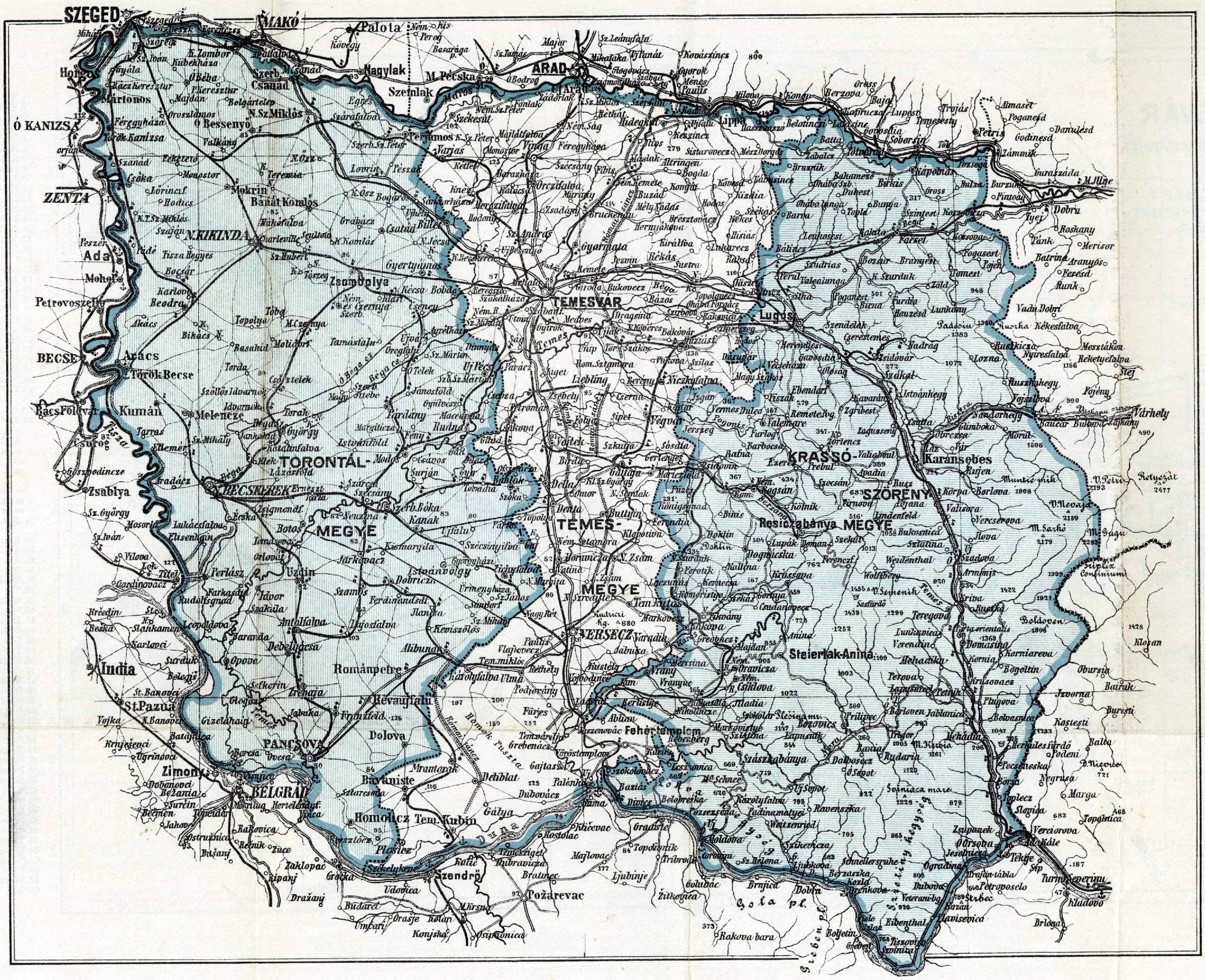
If you will analyze these counties -i.e. Torontal, Temes, Krasso-Soreny- using
the Lazarus
Maps, you will see that their
shape was "on vertical"/starting on the Mureş River [at North] and
ending at Danube River [in South] for Timiş County.
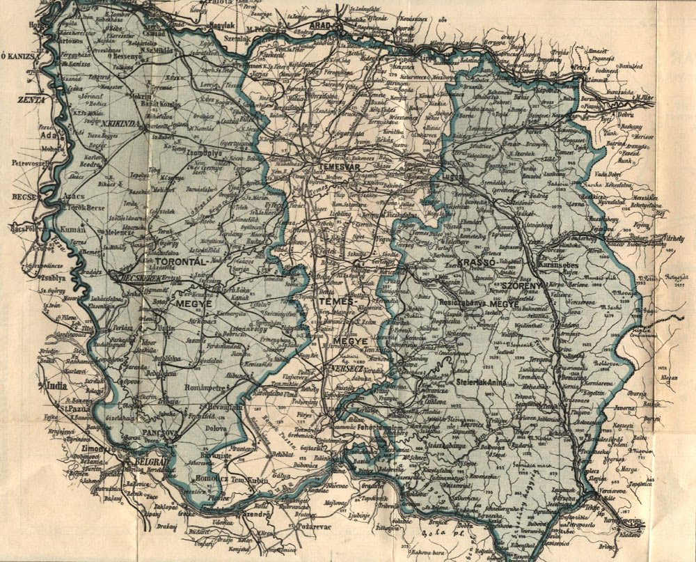
To see the old historical Banat [prior to WWI] and it's county shape and composition,
you can check the following map which was published in a book written by Dr.
Bodor Antal at the beginning of the XX Century:
Normal
Resolution [0.3 MB]
High
Resolution [1,7 MB]
If you will analyze the shape of today
Timiş County you can observe
that the shape is "on horizontal" [starting at the western border
of România and ending almost at the foothills of the Carpaţi Mountains].
If before WW I, Timiş County had 7110,56 km2; in our days Timiş County has 8678 km2.
NOTE:
[0]
In Romanian language: Banat / in German: Banat / in Hungarian: Bánát, Bánság / in Serbian: Banat, Banate, Banoviva / in Croatian: Banat, Banovina / in English: Banat / in Latin: Banatus / in Esperanto: Banato.
[1]
In fact, the information's are quite contradictory on this subject and each source of info will give a different number as Banat's surface. So, we can tell, without hesitation, that we do not know yet the exact surface of Banat!
Mureş (in romanian language) / Moros (hungarian) / Moravica (serbian) / Marosch, Mieresch (german)
Dunãrea (romanian) / Duna (hungarian) / Dunav (serbian, bulgarian) / Dunaj (slovakian) / Donau (german) / Danube (english) / Danuvius (latin) / Istros (greek), Ister (latinised greek) / Danu (celtic)
Tisa (romanian) / Tisza (hungarian) / Tisa (serbian) / Theiss, Theiß (german)
Bega (romanian) / Béga (hungarian) / Begej (serbian) / Bega (german)
Timiş (romanian) / Temes (hungarian) / Tamiö, Tamis (serbian) / Temesch (german) / Tibiscus (latin)
[2]
It seams that the term Donauschwaben was created around 1920 by Robert SIEGER [* 8.03.1864, Wien; + 1.11.1926, Graz], head of the Department of Geography at Graz University between 1905 and 1926. Under Sieger's leadership the Department of Geography shifted it's focus from the typical physical geography issues (lakes, glaciers, geomorphology) and regional geography to human geography. The circumstances in which SIEGER used the term Donauschwaben for the first time are shown probably in the article "Robert Sieger, Präger der Stammesbezeichnung Donauschwaben" published in "Beiträge zur Kenntnis der Donauschwaben. Gedenkschrift für Friedrich Metz den Freund der Donauschwaben", (Herausgeber unter Mitarbeiter von) Dr. Josef SCHRAMM, 1972, Stuttgart, Landsmannschaft der Donauschwaben in Baden-Württemberg, 175 pages, Donauschwäbisches Schrifttum; 16. Robert SIEGER's works.
The term was assumed also by Hermann RÜDIGER [1889-1946]. The first of his numerous study trips brought him in Banat in 1922. He was both in Romania and in the Kingdom of Serbs, Croats, and Slovenes / future Yugoslavia. The resultants of this visit were made publicly for the first time on 19.02.1923 during a conference held at the München University. In the same year, Hermann RÜDIGER published the text of the conference as a study entitled "Das Deutschtum an der mittleren Donau: (Ungarn, Südslawien, Rumänien)" and bearing the dedication "Den Donauschwaben und ihren völkischen Organisationen, dem Schwäbisch-Deutschen Kulturbund in Neusatz, dem Deutsch-Schwäbischen Kulturverband in Temesvar, der Deutsch-Schwäbischen Volksgemeinschaft im rumänischen Banat". In 1923, Dr. Hermann RÜDIGER was appointed as head of department at "Deutsches Ausland-Institut" / DAI and chief editor of the bimonthly "Der Auslandsdeutsche", the official publication of DAI between 1918-1938. "Deutsche Ausland-Institut" / DAI [i.e. German Foreign Institute] was founded in 1917 in Stuttgart as an academic think tank for cultivating and maintaining connections with emigrant Germans and people of German descent in foreign countries. DAI's name is to be found as Institut für das Deutschtum im Ausland / Deutsche Ausland-Institut / Deutsches Auslandsinstitut / Deutsches Auslands-Institut on Internet [more on DAI in Ernst Ritter's "Das deutsche Ausland-Institut in Stuttgart: 1917-1945: ein Beispiel deutscher Volkstumsarbeit zwischen den Weltkriegen", Wiesbaden: Steiner, 1976. - VI, 163 pages (Frankfurter historische Abhandlungen; Bd. 14)]. DAI's activity ceased in 1945 but will be resumed in 1949 by "Institut für Auslandsbeziehungen" / IfA from Stuttgart. From these leading positions inside DAI Hermann RÜDIGER could easily promote the new Donauschwaben concept to mark the Ethnic-Germans other then the Transilvanian Saxons [i.e. Siebenbürgen Sachsen / Erdélyi Szászok / Sasi]. Hermann RÜDIGER's works.
Some authors - as Josef BEER und andere in "Leidensweg der Deutschen im kommunistischen Jugoslawien, Band II: Erlebnisberichte über die Verbrechen an den Deutschen durch das Tito-Regime in der Zeit von 1944-1948" [Donauschwäbische Kulturstiftung, München / Sindelfingen, 1993, 1032 pages], at page 16 - give wrongly full credit to Hermann RÜDIGER for coining the term Donauschwaben in 1923. Even Rüdiger declared in 1938 that: "Als ich nach meiner ersten größeren Reise in den Südosten 1922 eine zusammenfassende Bezeichnung für die Deutschen am Mittelaufbau der Donau suchte, prägte ich zusammen mit dem … Geographen Robert Sieger in Graz das Wort Donauschwaben ...". It's still a mystery how they "coined / shaped" [in original prägte] together this term! More probably, Hermann RÜDIGER just borrowed the term from Robert SIEGER.
In 1935 the term Donauschwaben is used also in "Handworterbuch des Grenz- und Auslandsdeutschtums" [herausgegeben von Carl PETERSEN, Paul Hermann RUTH, Otto SCHEEL, Hans SCHWALM, vol. II, Breslau, 1935, pages 290-305].
The concept/name Donauschwaben was/is used only/mainly in scientific works.
Until the end of the WWI the term Ungarländische Schwaben was used for the Germans living in the countryside and Deutschungarn for those living in towns and cities of the former pre-WWI Hungary.
In the 1930's the term Volksdeutsche was introduced by the Nazis to designate the Germans who were not citizens of the Third Reich. During the time this term became a terminus technicus in scientific historiography.
[3] Vojvodatu Serbico et Temesiensi Banatu (in Latin language); Serbische Wojwodina und Temescher Banat (in German); Voievodina sârbeascã şi Banatul Timişan (in Romanian); Szerb-Vajdaság és Temesi-Bánság (in Hungarian); Vojvodstvo Srbija i Tamiški Banat (in Serbian); Serbian Voivodina and Timis's Banat (in English).
[4] 1688-1699: Szörény vármegye is again set up
27.12.1860 / 1861: Vojvodatu Serbico et Temesiensi Banatu region is abolished and Timiş/Temes, Torontál and Caraş/Krassó varmegye/counties are re-founded
1873: Szörény vármegy is refounded after the abolished on 8.06.1871 of the military border from the south of Banat and this region was linked again to Hungary on 1.01.1872
1880: Caraş/Krassó Vármegye/county is merged with Severin/Szörény county and the Caraş-Severin/Krassó-Szörény county [with it's capital at Lugoj] is set up
1926: Caraş-Severin county is split again in two parts: Caraş and Severin counties